|
<< Back to the main Local History page
Although, this O.S. map is dated 1937, the same map would have covered Lucan Village and surrounds up to 1960.
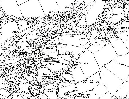
To the north are the fields of Westmanstown and Laraghcon. The residents of Weirview and Millbank, who worked in the nearby woollen mill, made up the population of this area back then. The site of a castle is identified, and at the end of Weirview, just at the entrance to Hillsborough, the site of 'Sunday Well' is marked.
To the south of the Liffey, and east of the bridge, the Rectory (now Old Rectory estate) is marked, and in place of the present boys school is an open field, then belonging to St. Edmundsbury.
The Village itself, has seen a few changes – a couple of the old buildings have been demolished and rebuilt; others refurbished, with new extensions and apartments close by; but the biggest change of all in this area is the arrival of Sarsfield Park around 1960. This estate would fill the fields between Main Street houses and the Main Road.
To the east of that area is the Old Spa House – the site of Lucan's Iron Spa. Close by, St. Joseph's Convent, St. Mary's Church and Graveyard, and Schools are identified.
Just look at the area between the Main Road and Esker Hill – Canonbrook, Clonard and Clonbrone are the only dwellings – about thirty years on, these 'empty' fields would begin to fill up with the estates of Esker Lawns, Lucan Heights, Beech Park and Cherbury Park. The convent schools would also expand into these open spaces.
To the west of the map is the Lucan Estate – the O'Connor Don was in possession of Lucan House and the area that now belongs to the Italian Embassy. Close by, the Castle and Church Ruins are identified.
South of the Lucan Estate, you can see the layout of The Orchard (now a modern development) and Primrose Lane, with The Manse. Close by, on the Lock (Newcastle) Road is the Souterrain at Moat Hill.
Hope you enjoy browsing through this map! Over the next few weeks, we hope to publish other parts of the same map, loaned by Peter Brady.
Mary Mulhall
|