|
<< Back to the main Local History page
This week, we visit our Fingallian neighbours on the north side of the Liffey. As one reader explained to me recently, they feel a bit left out of things in Lucan sometimes.

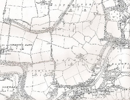
The map above is part of the 1937 O.S. publication, and while this area hasn't changed as much as some parts of Lucan in recent years, there are still a few items which warrant attention on this document.
For a better view of the map, visit the archives for August 2nd 2009
Probably the most historic thing in this area is the road going through it! Now known as the Clonee Road, it is part of a very ancient route, which came from Royal Tara, down through Lucan, and on through Clondalkin, as far as "The House of Hospitality" in Bohernabreena. We can only imagine the princes, merchants and holy men who must have travelled this route back in the early years. Closer to Lucan the hilly part of the road near Weir View, becomes known as Stanford's Hill – a reference to the Stanford family who lived in Ounavarra at the end of the 19th century.
Several accesses from this route made way to the rich farmlands in the area. Of particular note is the Black Avenue. Not identified by name on the map, it is the link between the Clonee Road and St. Catherine's, just north of Coldblow. The road connecting the Clonee Road and the Clonsilla Road by Luttrellstown is also to be seen.
North of the Black Avenue, in Westmanstown, is the Royal Canal and Dublin-Galway railway line, with Lucan Station (north) identified. Close to Collins Bridge, a Tow Path is marked – horses trod along here towing the canal boats before the age of motorisation. Shackletons transported some of their wares by canal boat back in the 1800s.
Between the Black Avenue and the Liffey the great houses of Glenwood, Hillsborough and Ounavara are marked, while further to the north, past the canal, is Allenswood House.
Towards the centre of the map is the townland of Laraghcon, with the old Larghcon House still standing – nowadays, a kitchen manufacturer is on this spot. South of this site, towards the Liffey is Clanaboy House – home to the Hill Family. The house was later used as offices for the CPI, and although not in use today, it is still standing on the laneway from the Low Road up to the old Laraghcon House site.
To the east of the map is Luttrellstown, with Tinker's Hill wending its way on the outskirts of the estate. At the top of Tinker's Hill is Mount Joseph (not identified by name) , while at the bottom of Tinker's Hill, is Anna Liffey Flour Mills (Shackletons), while further upstream is Millbank and Hill's Woollen Mill.
Several little homesteads are dotted along the roadways, which surround the patchwork of fields.
Seventy-two years on, the modern Laraghcon Estate fits into this map, as well as Marymount Care Centre, and Fort Lucan adventure centre!
Apart from CPI, the old industries are gone, but in their places are new businesses.
Several modern homes line the roads, but many of the old houses including Lucan Station House, are still home to present day Lucanians.

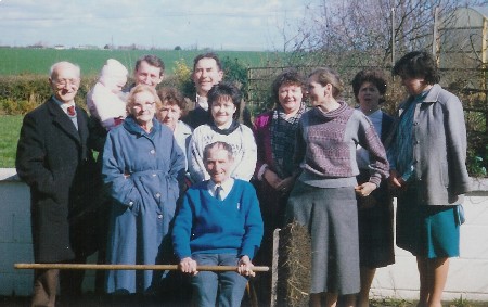
The above picture was given to me some years ago – the man seated is the late Martin Monaghan, who worked on the roads for Dublin County Council. Apparently when Martin retired, the residents of Westmanstown threw a party for him.
Back L-R: Jack Rafter, John McCarrick with baby, Larry Norris, Betty Nelson, Helen McCarrick, Angela Norris and Jacinta Maher
The three ladies just behind Martin are Josie Mahady, Una Coleman and Carol Norris.
Mary Mulhall
|

